


More than a dozen areas are under Storm Signal No. 2 due to the effects of Tropical Storm Basyang, which will bring life-threatening winds and heavy rainfall to affected areas, according to the state weather bureau on Thursday.
In its 11:00 a.m. bulletin, the Philippine Atmospheric, Geophysical and Astronomical Services Administration (PAGASA) stated that Signal No. 2 is in effect over Siquijor, the southeastern portion of Negros Oriental, the southern portion of Cebu, and the southern portion of Bohol in the Visayas.
It is likewise in effect over Surigao del Norte (including Siargao and Bucas Grande Islands), Surigao del Sur, the extreme northern portion of Davao Oriental, Agusan del Norte, Agusan del Sur, Misamis Oriental, the northern portion of Bukidnon, the northeastern portion of Lanao del Norte, the northeastern portion of Misamis Occidental, and Camiguin.
Under this wind signal, houses made of old or light materials are expected to sustain minor to moderate damage.
Meanwhile, Signal No. 1 is in place over Cagayancillo and Cuyo Islands in Luzon. In the Visayas, the signal covers the southern portion of Eastern Samar, the southern portion of Samar, Biliran, Leyte, Southern Leyte, and the rest of Bohol, Cebu, and Negros Oriental, as well as Negros Occidental, Guimaras, Iloilo, Capiz, Aklan, and Antique.
In Mindanao, the affected areas include Dinagat Islands, the northern and central portions of Davao Oriental, Davao de Oro, Davao del Norte, the northern portion of Davao del Sur, the rest of Bukidnon, and the northern portion of Cotabato. It also covers Lanao del Sur, the northern portion of Maguindanao del Norte, and the rest of Lanao del Norte, Misamis Occidental, the eastern and central portions of Zamboanga del Norte, the northern and central portions of Zamboanga del Sur, and the northern portion of Zamboanga Sibugay.
PAGASA noted that under this signal, light structures may sustain minimal to minor damage.
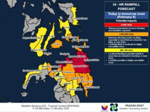
As for its track, Tropical Storm Basyang was last located 295 kilometers east of Hinatuan, Surigao del Sur, moving westward and accelerating to 25 kilometers per hour (km/h).
It has maximum sustained winds of 65 km/h and gustiness of up to 80 km/h. Strong to gale-force winds extend outwards up to 300 kilometers from the center, meaning areas not directly hit by the eye can still experience severe conditions.
Basyang is forecast to make its first landfall over Surigao del Sur tonight. It will then cross Mindanao and emerge over the Bohol Sea by Friday morning, potentially making a second landfall over Siquijor or the southern portion of Negros Oriental by Friday afternoon.
The storm is also likely to traverse Palawan by Saturday afternoon.
As a proactive measure, the provincial government of Surigao del Sur has announced the suspension of classes at all levels and work in government offices.
Meanwhile, the Department of Social Welfare and Development (DSWD)-CARAGA said in a statement that it has already activated its Division and Quick Response Teams.
PAGASA continues to remind the public, especially those in high-risk areas, to follow evacuation orders and instructions from local officials. — Edg Adrian A. Eva